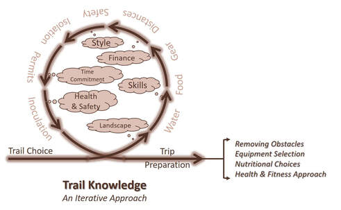
the overall planning process
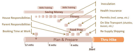
For us, the planning process is a series checklists on our living room wall. We will also start with a high level Gantt chart, the timeline with this type of chart, will help understand the big picture and ensure that we accomplish each major task on time.
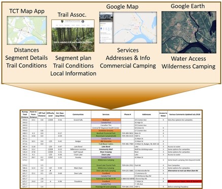
Building this plan is iterative, most of the information will be gathered progressively while researching the selected trail. Then, it is compiled as a logbook. The generic sites such as Traildino as well as the trail association websites provide much of the basic information. We may look at the trail with Google maps to see the communities along the way.
|
For tourist information such as travel restrictions, visas, healthcare, and other important information, it is important to pursue our own local government travel advisory sites and the destination travel sites.
As we build a more detailed logbook, it will be important to identify our needs. Eventually the plan will take shape. It will help guide us through the planning and preparation. This sample plan highlights the various steps we will need to address: |
- Scheduling Skills Training –This step may require several months and might include mountaineering skills, orienteering, wilderness first aid, or language courses.
- Saving Money – This step may be quite long. Saving money for all the expenses at home and on the trek is key. We build a budget for each trip.
- Fitness – We typically work with a fitness coach to increase our strength and endurance. We think of these treks as competitive events and schedule our peak fitness to coincide with the start date.
- Responsibilities – We consider our work and family responsibilities. These need to be addressed so we may leave for our trek, minimising the effect of our absence on others.
- Food Preparation – Are we purchasing food along the way, purchasing ready made meals, or making our own dried meals? Depending on our selection, it may require months of preparation.
- Miscellaneous – Activities specific to traveling including inoculations, travel insurance and health care coverage, visas, and passports all need to be addressed. On trail needs also requires scheduling these may include permits, shuttles, food drops, etc.
|
Over time we have simplified our lives to make this transition easier. We have met thru-hikers who have structured their work lives around the trekking season. One is a software technician; she works on contract six months of the year. She is a minimalist and lives to hike. Making enough money in the off-season to live comfortably and to be able to hike five or six months a year.
|
Logbook Information and Research - It is important to realise that not all treks have the same level of support. This is impactful because trails depend on their associations and communities not only for maintenance but also to provide valuable information to their users. New trails usually take years to build such infrastructure.
|
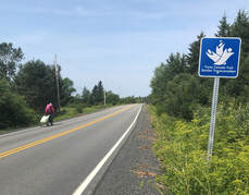
The Trans Canada Trail (TCT) was inaugurated in 2017. It is a mixed-use trail using roadways, riverways, and trails. A good base of information is in place, but it will take time and support from the organisation and most importantly from the user community to build useable data for thru-hikers. We tackled 12,500km on the Trans Canada Trail, from St John’s Newfoundland to Victoria British Columbia skipping a few thousand kilometers of waterways and the northern loop. We spent much of our off-season time building ‘Logbooks’ for ourselves. We now offer these to any hiker wanting to tackle all, or sections of this trail.
|
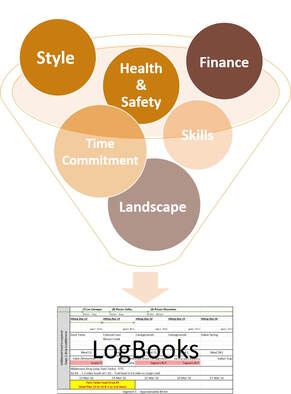
As we gather detailed data necessary for our thru-hike, we build our Logbook. They represent the relevant information needed in one place (electronically) for ease of use. Think of these files as the overall ‘architecture plan’ for a house.
|
Logbooks may include:
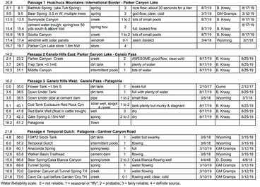
The first critical piece of data is the location of Water Sources. Water and how to find it along the way is critical; in fact, life will depend on it! Water may appear next to the trail on a map, but its accessibility and quality is not easily determined. Word of mouth from other thru-hikers is invaluable. |
We typically rate the sources 0-4. 0 being non-existent, to 4 being tap water. Some well supported treks offer an interactive App to help update water sources. This was the case on the AZT.
|
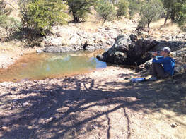
We crossed some dry sections and faced several questionable water sources on the AZT. We would pull out the AZT water app and read the comments other hikers had recorded a few days prior. During one memorable day, we read that a creek was down to a trickle, the comment had been made two days prior. It was our only water source for the rest of the day. We knew we needed water for our meal and the evening. We thought of it all day to finally find that this creek was still flowing when we got there. What a relief, after that we had a rule – never pass a water source without refilling your water containers!
|
Terrain difficulty and trail rating can be ascertained by looking at trail profiles and trail descriptions. This can help calculate the speed and distance travelled each day. Difficult terrain will slow us down and take more energy. A mountaineering motto states that a hiker adds an hour for each 305m (1,000ft) of elevation gain. If your known pace while hiking is 4km/hr (2.5mi/hr), you’ll need to add an hour for every 305m you climb. Ultra-light thru-hikers generally calculate 5+km/hr plus 30 minutes for every 305m in elevation gain.
Higher elevation will also require more effort. Hiking at elevations greater than 2,100m (7,000ft) will be more challenging due to the decreased oxygen levels. Our pace will be slower. Roadway walking, on the other hand, can speed our pace.
Other trail data from sources such as trail books or associations and their members provides much needed detail on trail conditions, weather conditions, risk factors (such as wildlife encounters), by-laws (such as no camping regulations along portions of the trail), etc. This detailed information is often only available on trail websites once you pay to become a member.
|
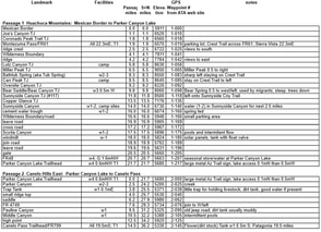
The Arizona Trail Databook is an example of the support available to trail members only. The file contains passage number, total miles, elevations, reference to GPS waypoints, water sources, campsites, trail head parking, and miscellaneous notes. The GPS way points, and total distance were important to us as we calculated our trekking days.
The information also informed our self-sufficient approach to nutrition and guided our locations for food caching. |
|
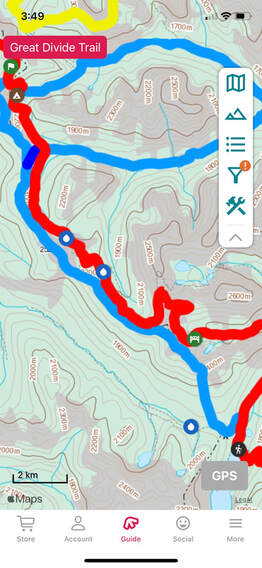
The digital topo maps also serve in the preparation of our journey. As with trail profiles, this data helps us understand the challenges and the predicted walking distances. They may be needed for orienteering on occasion. The FarOut Application for hand held devices is a 'must have' for any long trek.
Hikers Forum and Facebook Groups are a great way to communicate, ask questions and stay in touch as we plan our trip and during the thru-hike. Permits are usually an integral part of any long-distance trek. Can these be purchased ahead of time, or onsite? We make note on our logbook of costs, and contact numbers. We were vary impressed by the organisation around the AZT. There are several National Park crossings, including the Grand Canyon. Easily one of the most visited parks in America (if not the world). They have arranged a thru hikers’ process with a daily allotment of sites as you cross the canyon. We wanted to experience the Grand Canyon and requested a two-night crossing. We only waited an extra day on the rim and received the two-night crossing permits. A well-oiled machine indeed!
|
Campgrounds and parks - Most trails will cross campgrounds and or parks. These sites may offer some convenience stores, water, and camping. Note their location and contact numbers.
Gateway Communities, Trail Angels, Shuttles are three more items worth identifying. These components complete the necessary elements of our Logbooks. Communities are where we ship re-supply packages or schedule a zero day from time-to-time. For those and many other reasons, knowing what is available in a community is extremely helpful.
Gateway Communities, Trail Angels, Shuttles are three more items worth identifying. These components complete the necessary elements of our Logbooks. Communities are where we ship re-supply packages or schedule a zero day from time-to-time. For those and many other reasons, knowing what is available in a community is extremely helpful.
|
With our research complete, our logbook answers these questions:
|
As we compile the required data, we also create a quick visual aid with colours and codes. It really helps us on the trail, one quick look in the morning or at night and we are set.
final thoughts on trail knowledge
There is no one-approach to researching trails. Our logbook approach works for us. Long-distance journeys are difficult to prepare and execute. Gathering the appropriate amount of knowledge and capturing it in a usable form increases our enjoyment of both planning and executing our thru-hikes.
|
Everyone will have unique needs such as traveling with a pet, special nutritional needs, and so on.
Long-distance hiking is seeing a dramatic increase in popularity. Access to information will improve. We always remind ourselves to keep concentrating on the fundamentals of long-distance hiking, such as: food, water, gear, distances, safety, self-sufficiency, and pre-trip logistics. |
We learn every time we take on a thru-hike. We review blogs and other types of trip reports which help us understand specific details for each trail. Planning is everything!
Next step is 'Removing Obstacles'

