JUSI ADVENTURES
Picture

Planning for the Trans Canada Trail

Picture
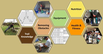
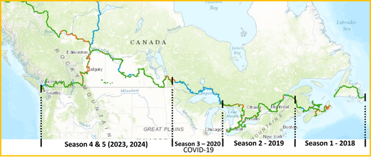
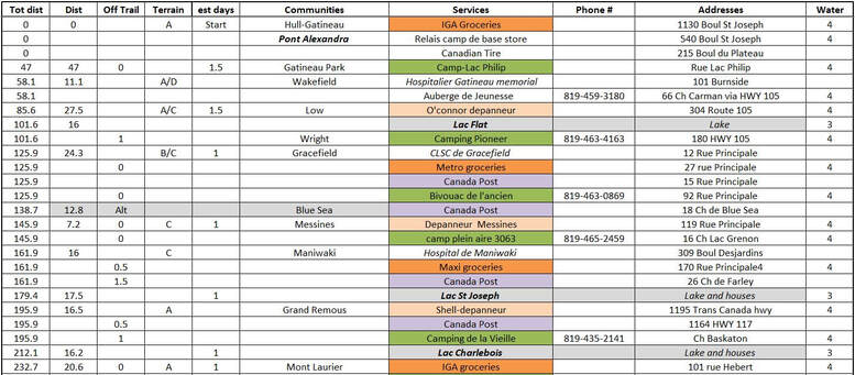
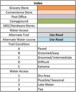
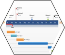
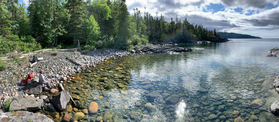
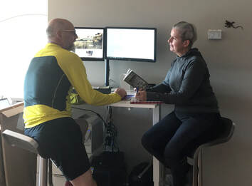
Once a preliminary research is accomplished and we move forward with the detailed planning process our approach is very consistent. This page offers a glimpse of the detailed itinerary and preparation specific to the Trans Canada Trail. 
  • Home
  • Planning Our Adventures
    • Trail Choice
    • Trail Knowledge
    • Removing Obstacle
    • Equipment >
      • Base Weight
      • Thru-Hiking Clothing
    • Health and Fitness >
      • Why Walk?
      • Favorite Exercises
      • The Art & Science Of Walking
    • Nutrition >
      • Nutritional Fundamentals
      • Menu Planning
      • Dehydrating Your Meals
      • Favorite Meals
  • Sharing Our Adventures
    • The Trans Canada Trail >
      • TCT Planning
      • JUSI TCT Blog
    • The Rideau Trail >
      • Rideau Trail Planning
    • The GR20 >
      • GR20 Planning
    • Annapurna - Poon Hill Circuit >
      • Ghoripani Trail Planning
    • Camino Frances >
      • Camino Frances Planning
      • Camino Frances Journey >
        • Camino Frances Planning Blog
        • Camino Frances Part 1 Blog
        • Camino Frances Stage 2 Blog
        • Camino Frances Part 3 Blog
        • Camino Frances Post Mortem
    • Camino Le Puy en Velay >
      • Camino Le Puy Planning
    • The Arizona National Scenic Trail >
      • AZT Planning
      • Arizona Journey >
        • AZT Pre-Trip Blog
        • AZT Journey - Stage 1
        • AZT Journey - Stage 2
        • AZT Journey - Stage 3
        • AZT Journey - Post Mortem
    • The Great Divide Trail >
      • GDT Planning
      • GDT 2022 Pre Trail Blog
      • GDT Section A Blog
      • GDT Section B Blog
      • GDT Section C & D Blog
      • GDT Section E Blog
  • About
  • Contact Us
Picture

Trail Knowledge

Thanks to the great work of the Trans Canada Trail Organisation (website) and their members (Facebook and blogs), we acquired a good deal of the information needed to create our work sheet. Google maps and the trail app were also invaluable.

There were also provincial trail books available, but they were 10 years old and some of the information was no longer relevant or accurate.
Picture
This is our current plan for completing the TCT
​Our TCT Worksheets were created by province. They include distances between communities, trail ratings, water sources (their reliability), and grocery stores nearby. Our itinerary preparation is calculated with an average of 25 km/day for the TCT. Our research is a deep dive in order to understand locations of supplies and services.  Along TCT, we have gathered this type of information using Google Maps, the TCT application map and various provincial books (most are 8-10 years old). This information is considered moderately accurate. We update our logbooks as we walk the trail - the Maritime Provinces, Quebec, and Ontario have been updated - as of January 2022.
​We have built our logbooks by province (available below). In these datafiles, we have calculated; distances (both cumulative and between services), distance off-trail (if applicable) for any services, types of terrain expected, communities and services, phone numbers for campgrounds, addresses and water access. We use this information to plan our resupply points, understand when we need to carry more water, and where we can expect to rest and camp (maybe even shower!).
Picture
There are some alternate sections where the trail may be too rugged for our 'wheelie'. We have opted to use secondary roads in these areas. This may be useful for cyclists and others who want to stay away from very rugged trails. For significant water trail sections, we've also chosen some roadway alternatives.

​The Index (right) is important to quickly decipher the type of services outlined in our logbooks.  
 
We hope that our research will be helpful for anyone planning to undertake significant sections of The Trans Canada Trail. ​
Picture

Updated Provincial logbooks (post thru-hike)

The Province of Newfoundland - (post trail updated November 2018) 
approximately 900 km of moderate multi-use trail on the T'Railway Provincial Park
nfld_data_file_2018-08.pdf
File Size: 366 kb
File Type: pdf
Download File

The Province of Nove Scotia - (post trail updated November 2018) ​
approximately 715 km of mixed of roadways and moderate trails with a waterway section.
ns_data_file_2018-11.pdf
File Size: 416 kb
File Type: pdf
Download File

The Province of Prince Edward Island (post trail updated November 2018)  
​
approximately 450 km of well groomed paths on the Confederation Trail
pei_data_file_2018-11.pdf
File Size: 380 kb
File Type: pdf
Download File

The Province of New Brunswick (post-trail updated November 2018)
approximately 922 km of mixed trails and roadways with a waterway
nb_data_file_2018-11.pdf
File Size: 429 kb
File Type: pdf
Download File

The Province of Québec (post-trail information updated July 2019)
approximately 1418 km
que_data_file_2019-07.pdf
File Size: 709 kb
File Type: pdf
Download File

The Province of Ontario (post-trail information updated October 2019)
approximately 4172 km
ont_data_file_2019-10.pdf
File Size: 774 kb
File Type: pdf
Download File


Planning PROVINCIAL LOGBOOKS (pre THRU-HIKE)

The Province of Manitoba (pre-trail information created December 2019)
approximately 1330 km
manitoba_data_file_2019-12.pdf
File Size: 357 kb
File Type: pdf
Download File

The Province of Saskatchewan (pre-trail information created December 2019)
approximately 1380 km
saskatchewan_data_file_2019-12.pdf
File Size: 315 kb
File Type: pdf
Download File

The Province of Alberta (pre-trail information created December 2019)
approximately 1215 km
alberta_data_file_2019-12.pdf
File Size: 314 kb
File Type: pdf
Download File

The Province of British Columbia (pre-trail information created December 2019)
approximately 1710 km
british_columbia_data_file_2019-12.pdf
File Size: 490 kb
File Type: pdf
Download File


The GPX Files are available from The TCT App - in the app, simply select the measuring tool (the ruler icon) then choose the 'export highlighted trail' option. A GPX will be available for download. We have not used these GPX Files, we found that the iPhone App using the GPS location is more than sufficient for our journey.
Picture

Removing Obstacles

Financial:
  • There were a few campsites along the trail. Reservations were made onsite. Fees ranged from $30 to $60 per night.
  • We planned on having rest days in some of the communities. The accommodations were booked onsite. 
Time Commitment:
  • Our walking season for the TCT started in early spring (mid-May) and continued until the weather became too cold for comfort (mid-Oct).
  • Hiking, cycling, canoeing, or skying the TCT can be done anytime of year. Bear in mind that it can be quite buggy in the spring, and quite cold in the winter.
Picture
Health and Fitness:
  • The terrain on the TCT ranged from flat to mountainous. Having a good fitness base and a good walking technique, helped minimise injuries.
Skills:
  • This trail was not always well marked and crossed many communities and city parks. Having some orienteering was advisable.
  • Some backcountry camping skills and ‘leave no trace ‘camping practices were useful as stealth camping along the trail was often not permitted but necessary. 
Picture

Equipment

On the TCT, we carried water and our clothing in our backpacks. The Wheelie (our cart) carried the rest of our equipment.
  • We chose our 4-season tent without its fly. We used a lightweight tarp instead. This shaved off 400g. The shelter was much appreciated as bugs were a concern in this environment. We were thankful for its protection during our rest periods and on those rainy nights.
  • We wore a variety of running shoes and hiking boots. The shoes dried faster than boots but did not last as long as the hikers did.
  • We used Aquafina drops to purify the water. The drops worked well.
Picture
  • We used the Ohuhu wood burning stove and a Whisper-light stove with fuel cannisters for rehydration. The Ohuhu worked well for heating less than a liter of liquid, but for more volume we preferred the whisper-light stove. It boiled water quickly for our meals and hot drinks.
  • As we crossed a community every 2-3 days, we did not carry a lot of dry food stores. We had a few soup bases and some instant rice. But we purchased most of our food from the local shops along the way.
  • We carried luxury items such as our 2 camp chairs (which we used a lot during our breaks) and a few books (which we never read).
There is additional information in our 'Equipment Section'.
Picture

​Nutrition

Our menu plan for this trek included a few soup bases, instant rice, and snacks such as nuts, dry fruit, and sausages. We purchased our supplies at local grocery stores along the way. Upon crossing a town, we would calculate the distance to the next grocery store and purchase enough goods to last us until then. The grocery stores made it possible to eat a lot of fresh foods most days.

Without fresh foods, our nutritional approach on the TCT was based on items we communally found in 'small town' grocery stores. mainly when away from towns for more than two days. The table is a basic outline of the food and its nutritional value. For additional information please refer to our general Nutrition web page. 
Picture
Picture

HealTH & Fitness

Our winter fitness program maintained a good base. But as the new walking season came about, we started increasing our walks.

For detailed information on our exercise routines check out our Exercise web page.
​
Picture

Home Page

​  About JuSi Adventures

Sharing Our Adventures

​The Trans Canada Trail 
​The GR20
​Annapurna Circuit
​Camino Frances
​Camino Le Puy en Velay
The Arizona National Scenic Trail​
The Rideau Trail
The Great Divide Trail

Planning Our Adventures

Trail Choice
Trail Knowledge
Removing Obstacles
Equipment
​Health and Fitness
Nutrition

The Art & Science of Thru-Hiking

​Contact Us

© COPYRIGHT 2015. ALL RIGHTS RESERVED.
  • Home
  • Planning Our Adventures
    • Trail Choice
    • Trail Knowledge
    • Removing Obstacle
    • Equipment >
      • Base Weight
      • Thru-Hiking Clothing
    • Health and Fitness >
      • Why Walk?
      • Favorite Exercises
      • The Art & Science Of Walking
    • Nutrition >
      • Nutritional Fundamentals
      • Menu Planning
      • Dehydrating Your Meals
      • Favorite Meals
  • Sharing Our Adventures
    • The Trans Canada Trail >
      • TCT Planning
      • JUSI TCT Blog
    • The Rideau Trail >
      • Rideau Trail Planning
    • The GR20 >
      • GR20 Planning
    • Annapurna - Poon Hill Circuit >
      • Ghoripani Trail Planning
    • Camino Frances >
      • Camino Frances Planning
      • Camino Frances Journey >
        • Camino Frances Planning Blog
        • Camino Frances Part 1 Blog
        • Camino Frances Stage 2 Blog
        • Camino Frances Part 3 Blog
        • Camino Frances Post Mortem
    • Camino Le Puy en Velay >
      • Camino Le Puy Planning
    • The Arizona National Scenic Trail >
      • AZT Planning
      • Arizona Journey >
        • AZT Pre-Trip Blog
        • AZT Journey - Stage 1
        • AZT Journey - Stage 2
        • AZT Journey - Stage 3
        • AZT Journey - Post Mortem
    • The Great Divide Trail >
      • GDT Planning
      • GDT 2022 Pre Trail Blog
      • GDT Section A Blog
      • GDT Section B Blog
      • GDT Section C & D Blog
      • GDT Section E Blog
  • About
  • Contact Us